|
Site Index
Kemano
Kemano Beach
Powerline
Kemano Tunnel
M-K Tramway
Kemano Powerhouse
Kemano Townsite, Camp 5
Wachwas Camp
Company Phone Book 1954
Workers in Memoriam
Kitimat
Alcan Smeltersite
Labour Management Committee
Kitimat Townsite
Nechako Reservoir
Ootsa Lake Lodge
Managers
Ray Edwin "Rep" Powell
McNeely "Mac" Dubose Jr.
Misc.
G.G. Massey's
Visit 1954
T.R. "Bud" Walker
Morrison-Knudsen Co.
Crawley & McCracken Co. Ltd.
Horetzky (Peak, Creek, St,)
Jeff Watts Photos
Jeff Watts Bio
Kemano Boy Scout Troop
Various Photos, ca 1954-56
Jim Hanna Photos
Various Photos ca 1954-56
External Sites
External Links
Contact
Web Editor |
NO Reproduction in Whole or in Part, on
ANY, and ALL of my Pages,
Including Text and Pictures,
May be made, without the express Written Permission
of Web Editor, Doug Gent
© 2016
Want to add a link to my
pages?
see my
Contact
Web Editor Page
for the only Authorized Picture Link allowed.
All Pictures on all my web pages, are now Visibly Watermarked,
All my pages are now Right Click, copy and paste, disabled.
I ask everyone that enjoys free history sites,
to start to policing these violations.
If we don't stop this, no one will donate pictures to me or anyone,
and we all loose.
If you see one of my pictures on facebook, etc.
tell them to remove it.
Wachwas Camp
View Larger Map
Wachwas Camp was a couple miles closer
to the Beach
area, than Camp 5.
It was for the married men, and Management.
It had house trailers, and prefab houses.
It was located at Seekwyakin Creek, just to the north of the camp
a tributary of the Kemano river,
even though there really is
a Wachwas Creek,
but it was closer to the Beach.
the turn off from Kemano Dr., the road to the beach,
is located at
Latitude-
53 deg 33 min 47.43 sec N-
Longitude- 127 deg, 56 min 33.78 sec W
As they built the road from the Beach, they created
camps.
each one was given a number as they went.
I guess when they got to the powerhouse area,
they were at number 5, thus it became Camp 5.
Not sure why Wachwas camp wasn't a number like the rest.
Interesting bit of trivia to figure that out.
 
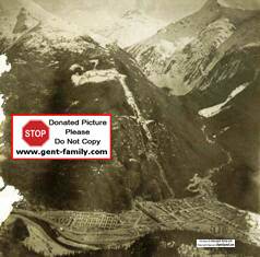
Explanation of these photos below from Mr.Grant Walker.
This is a picture
of the housing for the family's of white collar
and skilled labour the company needed.
Called Wachwas Camp, but actually located at Seekwyakin Creek.
Left to right. Turquoise
arrow is were we lived when we first arrived in Kemano.
It was a small trailer for the 4 of us. (see below)
Next Turquoise arrow is of the
house we moved to.
Yellow arrow is of company store.
Food and more important trading cards for me.
These were of tanks and big guns.
All us kids use to trade them with each other.
Next Turquoise arrow is of school
for us kids.
Classes were of many grades in the same room and same teacher.
Not enough of us little brats to go around.
Red arrow below road near river
is skating rink.
Company dug it out. It was very shallow
and water was very slow moving and would freeze in the winter.
If you look a little farther left from my trailer.
At rivers edge that is were the picture of my brother and I was taken
with the 7 on the mountain. (see below)
That will show you how far it was to the power house.
Last shot is of same place.
As you first enter off the main road it is all trailers on your left
except in the fore ground.
If you look closely at the trailers you will see roof of longer
buildings.
These are toilets and showers.
Half was for women, half for men.
There was no toilets or showers in the trailers
1954- a 5 room school, grades 1 to 9
The
Principal was a Mr. Gleddie
Library operated by M-K librarian, Miss Catherine Pearce.


Trailer as described above.
top photo-
"Bud" Walker, wife Bertie Walker, son Ayce Walker.
taken by Grant Walker
Bottom photo- another view of the trailer, with joey shack,
shower/toilet building in background

Wachwas Camp looking toward the beach
 
Pictures from Grant Walker
Showing the house the family lived in,
Skating rink the kids played on,
fishing everyday,
and even a picture of the Kemano dump!
Bottom of left picture background is the Kemano dump
Skating rink was across the road from the Wachwas Camp.
Of course the snow had to be hand shovelled off it.

Top Photo- snow capped mountain
Bottom photo-
Left front is Mr. Grant Walker (who donated these photos)
Right front- his brother Ayce Walker.
this is at Seekwyakin Creek, beside Wachwas
Camp


Left-
Jane (Jay) Mary Brown, wife of "Al" Brown
Right-
Albert (Al) James Brown, from England
working at their home at Wachwas Camp
All photos courtesy Grant Walker,
from his father, Thomas Raymond Walker's collection
Solve a
Mystery
Got this email from a fellow whose Dad
worked in Kemano
"My name is Bob Jordan. my Dad was the Safety Supervisor at Kemano from 1958 to
1968. In 58 I recall going up the skip at Wachwas and entering a tunnel at the
top. We went as far in as we could go about 100 m. at that point there was a
wall with a steel door. No one seams to have any memory of it. wondering if you
might recall it and if you know what was the purpose of it?
They were decommissioning the skip way at this time, Bob told me later
is the reason they were up there.
It went up about 800 ft.
Landing was just back of the trailers.
Now this was a large Tramway (Skip Way) that an
ambulance fit on it,
also it WAS BEHIND Wachwas Camp,
NOT the MK one up Mt. Dubois,
from the main camp 5.
If you know who built this and what was it for
please let me know.
the way it was sealed off by steel doors,
is the same way the tunnel adits were sealed off.
but was it built for Kemano, or before Kemano?
Possibly an old mine?
Grant Walker remembers seeing an old small cable
running up the mountain, but that's about it.
|


