NO Reproduction in Whole or in Part,
on ANY, and ALL of my Pages,
Including Text and Pictures,
May be made, without the express Written Permission
of
Web Editor, Doug Gent
© 2016
Want to add a link to my
pages?
see my
Copyright Information
Page
for the only Authorized Picture Link allowed.
All Pictures on all my web pages, are now Visibly Watermarked,
All my pages are now Right Click, (copy and paste), disabled.
I ask everyone that enjoys free history sites,
to start policing these violations.
If we don't stop this, no one will donate pictures to me, or anyone,
and we all loose.
If you see one of my pictures on Facebook, etc.
tell them to remove it.
First Hillside School, #1 on map, was built in 1912
at 721 Henry Street
The 2nd and Last Hillside
School, #2 on map
was built at 637 Eva St.
In Estevan
Saskatchewan
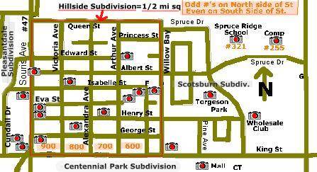
Click on the camera in the
map below
to view pictures of that item or area.
Move your mouse to the camera
to see the caption and letter
which should match a key element below

Map Key
#1- First Hillside School- 721 Henry St
#2- 2nd Hillside School- 637 Eva St
#3- Scotsburn School
#4- Spruce Ridge School
#5- Estevan Comprehensive School (ECS)
#6- St. Mary's Catholic School
A = 5th Estevan Scout Hall (no longer there)
B = St Peter's Lutheran Church (my church)
C= Louie Boey's store (Funeral Home now)
D = Little J's convenience store
E = Old Texaco Garage,
F = Dufferin Ave
G= Kensington Ave
H = OK Economy and Bowling Alley
I = 837 Isabelle St, (where I lived)
J = Hillside Kinsmen Park
K = First Apartment Blocks built in Hillside
L = Kinsmen School for Handicapped children
M = Old Texaco garage in front of OK Economy
900, 800, 700, 600 = Blocks of House Numbers
Original Hillside subdivision would have been
a full Quarter Section of land, 1/2 mile square.
from King St North for half a mile to Queen St.,
then Souris Ave, also called Highway 47,
East for half a mile to Willow Bay.
A full mile East would be Kensington Ave.
So legally it was located at
SW part of Section 26, Range 8, Township 2, W2
Apr 4, 1884 Hudson Bay Company owned the land.
It was subdivided in 1912
To the east is Scotsburn Subdivision
South of King St is Centennial Park Subdivision,
Pleasantdale Subdivision to the West of Souris Ave.
Hillside Addition Subdivision to the North,
and Maple Grove subdivision north of the Comp.
But in my mind, everything North of the tracks,
and East of the ravine was Hillside.
